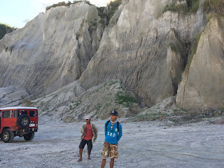
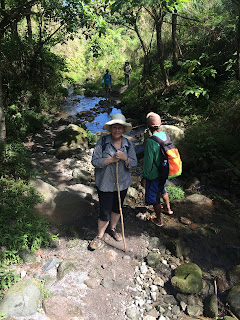
President Clark and I finally made it to Mt. Pinatubo. We were celebrating both of our birthdays. It was fascinating! Here is some information on Mt. Pinatubo.
Before 1991, Mt. Pinatubo was an unremarkable and heavily
eroded mountain. It was covered in dense
forest which supported a population of several thousand indigenous people, the
Aeta. The were a hunter-gathered people who
were extremely successful in surviving in the dense jungles.
In mid-March 1991, villagers around Mt. Pinatubo began
feeling earthquakes and after several explosions a Level 5 alert was issued
indicating an eruption was in progress.
On June 15th 1991, the second largest volcanic eruption of
the twentieth century took place when Mt. Pinatubo erupted at 1:42 p.m. local
time. The eruption lasted for nine hours
and caused several large earthquakes which results in the collapse of the
summit and the creation of a caldera.
At the time of the eruption, Tropical Storm Yunya was passing
to the northeast of Mt. Pinatubo, causing a large amount of rainfall in the
region. The ask that was ejected from
the volcano mixed with the water in the air caused a rainfall of tephra that fell
across almost the entire island of Luzon.
There was 10 cm of ash covering an area of 2000 square kilometers and
most of the 800 people who died during the eruption died due to the weight of
the ask collapsing roofs. Had Tropical
Storm Yunya not been nearby, the death toll from the volcano would have been
much lower.
The human impact of the disaster was staggering. In addition to the 800 people who lost their
lives, there was almost half a billion dollars in property and economic
damage. The economy of central Luzon was
horribly disrupted and the Aeta people were the hardest hit. The total destruction of many villages meant
that many Aeta were unable to return to their former way of life. The volcanic eruption and two typhoons that
entered the area when the volcano was erupting, turned the breadbasket of the
Philippines into a desolate waste land.
After the eruptions ended, a crater lake was formed which was
hot and highly acidic. Abundant rainfall
cooled and diluted the lake and increased its depth by about 1 metre per month
on average. In September 2001, fears
that the walls of the crater might be unstable prompted the Philippine
government to order a controlled draining of the lake. Workers cut a 5 metre notch in the crater
rim, and successfully drained about a quarter of the lake’s volume.
Breathtaking!
The Aeta (pronounced as “eye-ta,”), Agta or Ayta are an indigenous people who live in scattered, isolated mountainous parts of Luzon, Philippines. They are considered to be Negritos, who are dark to very dark brown-skinned and tend to have features such as a small stature, small frame, curly to kinky afro-like textured hair with a higher frequency of naturally lighter hair color (blondism) relative to the general population, small nose, and dark brown eyes. They are thought to be among the earliest inhabitants of the Philippines, preceding the Austronesian migrations.
Along the trail the Aeta tribe has a little hut up for refreshment and rest. They are a friendly people. There is little opportunity for many of them to ever leave. It is such a difficult trek to get into their area. We saw some motorcycles driving toward their land but I'm not sure how they make it through the riverbeds. Rainy season could be very treacherous.
The skilled driver and guides are definitely necessary in order to have a successful trip.


No comments:
Post a Comment
Note: Only a member of this blog may post a comment.